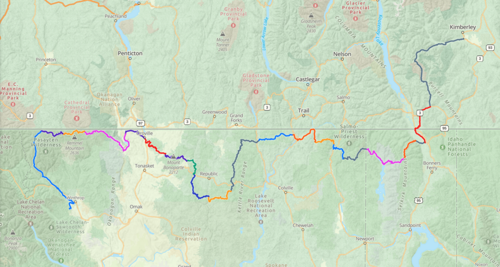
It’s time to commit to this! So here it goes: I am less than 3 weeks away from my planned departure date on what I now call “KIM2PINE”. This is short for walking from my house in Kimberley BC to my neighbourhood in Pine Forest, outside of Winthrop WA. Overall I am calculating it at roughly 1000km, and I’m hoping to finish the hike by the end of August. 33 days of walking, flexibility for 2 zeros (days with 0 miles hiked) along the way, and I should make it by August 30 or so.
As for the route: I am plotting my own way through the mountains south of Kimberley and west of Cranbrook, to arrive at Highway 3. From there I will make it to either the Kingsgate or Rykerts border crossing … one cannot cross the border to the US in the forest on a trail, it has to be at an official border crossing.
About about 15km hiking south of the border, I will reach the PNT – the Pacific Northwest Trail. This trail travels 1200 miles from Glacier National Park in Montana to the Olympic Mountains and the ocean in Washington State. My hike will cover roughly 460 miles on the PNT going west, then I will turn south onto local trails from the Pasayten Wilderness north of Winthrop, and hike into Mazama, then Winthrop, then Pine Forest.
Due to recent developments in my life, it seems like a good time to hit the trail, find solitude and community, peace and hopefully some positivity about life. If my journey on the PCT was any indication, it will be challenging and rewarding.
The PNT is definitely more wild and remote than the PCT. Bushwhacking sections are common, as are road walks. I once hiked a section of the PNT from Ross Lake, WA, to Oroville, WA, through the Pasayten Wilderness. That stretch will definitely be the highlight as far as scenery goes! My resupply points will probably be Creston, Metaline Falls, Northport, Republic, and Oroville. The last section is the longest food carry at about 132 miles so I will be the one inhaling food at the Mazama Store once I get there!
Here is an outline of the route:

If necessary, I can cut it shorter at the end by turning near where it says “Remmel Mountain” and heading straight south and into town.
With regards to gear, some items carry over from the PCT, such as my tent (Zpacks Duplex) and quilt (Katabatic Flex 22). I have a new backpack (KS Ultralight 50), and am still debating which pad to use (CCF foam or inflatable). Cook set, water filter, clothing and other items are pretty much the same. I will post a more detailed gear review soon!
I will be sending location check-in’s every night, and they will be viewable on my Garmin inReach map here: Map
In addition, I will try to write posts with pictures here on the blog. Make sure to subscribe, and leave comments if you have time to do so!
Update:
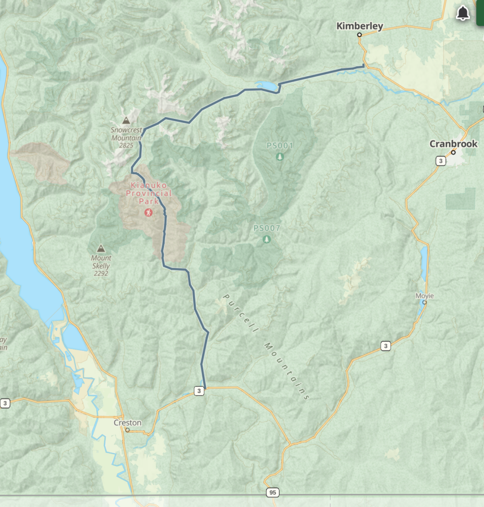
After talking to numerous logging companies, ministries and outfitters, I have decided on the “Meachen” way to get to the border. See this map:

This route, while starting on a road, is not only pretty through Kianuko Provincial Park, it also has good established horse trails all the way from the highpoint near Haystack Lake down the Kianuko drainage to Skelly Creek and then Goat River (that road goes all the way to Kitchener). No logging, quiet and scenic. Once I get to Highway 3, I might have to hitch a ride since there is no trail from Kitchener to Creston (only highway and railroad). From the Rykerts border crossing south of Creston it’s only about 12km to the PNT. I am able to resupply my food in Creston and hit a stretch of about 115 miles from there to Metaline Falls.

Wünsche Dir viel Spass,pass auf dich auf.Werde jeden Tag mal schauen wie es dir geht und was du erlebt hast.
Oliver
Danke danke! That means a lot! Make sure to check the Garmin link for daily progress …
Quite an ambitious trek you have planned. I hope the temperature isn’t so extremely hot during the hike. Be safe out there and don’t take any risks you don’t have to. I look forward to tracking your progress. All the best.
Thanks Mel! Another epic challenge … hope the heat passes. I will be safe and will hear your voice in my head! The trickiest part is to get to the border; once on the PNT at least the route is clear!
Have been wondering what you have been doing these past several years Biggie??now I KNOW! I will definitely follow your progress even though I will be back home in Australia.
I assume you are travelling solo?? 😏
Yes I will be! So great to hear from you! Enjoy your Oz travels …
You are the best hiker I ever knew -Looking forward to “travelling” with you
Aww thanks Joyce! It means a lot that you’re following along!!